 |
|
Well
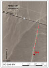
No. NC-GWE-8PA
SITE SUMMARY AND DATA |
|
Status:
Completed on
06/02/2010
Latitude/Longitude (NAD 83) - Approximate:
36°
37' 27.92" N
116° 22' 37.50" W
Legal Description:
T15S R50E S29 NW 1/4
|
Total Depth of Borehole
(ft): |
448.2 |
|
Total Depth of Well
(ft): |
435.5 |
|
Elevation of Ground Surface
(ft amsl): |
2660.0 |
|
Elevation of Water
(ft amsl): |
2323.6 |
|
Depth to Water
(ft bgl): |
336.4 |
|
Screened Interval
(ft bgl): |
330-430 |
|
Sandpack Depth
(ft bgs): |
328-448 |
|
Estimated Airlifted Water Production
(gpm): |
0.5-1 |
Alluvium Thickness
(ft):
(depth
to water values based on post-drilling measurements
taken in March 2011)
|
+448 |
|
Contact Intervals
(ft bgl) |
Stratigraphic Unit |
|
0-16 |
Silty Sand with Gravel |
|
16-20 |
Well Graded Sand with Silt and Gravel |
|
20-25 |
Well Graded Gravel with Sand |
|
25-95 |
Well Graded Sand with Gravel |
|
95-270 |
Clayey Sand |
 Access:
From the intersection of US Highway
95 (US 95) and Highway 373, head
east on
US Highway 95 about
1.5 miles and turn right onto an unnamed dirt road.
There is an unlocked gate at the edge of the US 95
right-of-way. Proceed south along the dirt road about 0.9 miles to the cleared
well pad
area on the left.
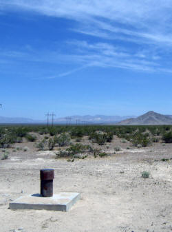
Click on the
thumbnail image
for a larger view. Access:
From the intersection of US Highway
95 (US 95) and Highway 373, head
east on
US Highway 95 about
1.5 miles and turn right onto an unnamed dirt road.
There is an unlocked gate at the edge of the US 95
right-of-way. Proceed south along the dirt road about 0.9 miles to the cleared
well pad
area on the left.
Click on the
thumbnail image
for a larger view.
Purpose
- Water Resource Conditions in the Amargosa Desert:
NC-GWE-8PA is one of seven boreholes and monitoring
wells to:
1) collect baseline flow and chemical data south and
west of the Nevada Nuclear Security Site, and 2)
determine head relationships near the Gravity fault
to help determine the role of the Gravity fault in
restricting or facilitating groundwater flow in the
Amargosa Valley.
Data:
|
RID |
Description |
Data |
Metadata |
Date |
|
Well
Completion Diagrams |
|
7798.01 |
NC-GWE-8PA Well Completion
Diagram |
rid7798_01.pdf |
meta7798_01.pdf |
4/15/11 |
|
Geophysical Data |
|
7779 |
NC-GWE-8PA Open Hole Geophysical
Logs, including: natural gamma, 8-, 16-,
32-, and 64-inch normal and lateral
resistivity, fluid temperature, fluid
resistivity, and caliper logs.
Data collected on 6/01/10; Data are in
log ASCII format (.las). |
rid7779.zip |
meta7779.pdf |
10/11/10 |
|
7848 |
NC-GWE-8PA Completion Geophysical
Logs, including: natural gamma, 8-, 16-,
32-, and 64-inch normal and lateral
resistivity, fluid temperature, fluid
resistivity, and density logs.
Data collected on 12/18/2010; Data are in
log ASCII format (.las). |
rid7848.zip |
meta7848.pdf |
4/14/11 |
|
Ground Water Chemistry |
|
7966 |
NC-GWE-PV-1, PV-2, PV-3, 2P, 8PA,
Felderhoff-25-1PA, GF-3PA, GF-4, GF-4PA,
OV-1, OV-2, NPS well AM-0501 (GF-1), and Inyo BLM #1
Ground water chemistry results including
major ions, nutrients and metals from
ACZ Laboratories, Inc.; SIRA of nitrogen
in nitrate from Isotech Laboratory;
gross alpha and beta, radium, and
uranium from Radiation Safety
Engineering, Inc.; and SIRA of carbon in
TDIC, Radiocarbon (C-14) from Beta
Analytic for the
collection period from 3/21/2011 -
6/23/2011. |
rid7966.zip |
meta7966.pdf |
3/15/12 |
|
7974 |
NC-GWE-PV-1, PV-2, PV-3, 2P, 8PA,
Felderhoff-25-1PA, GF-3PA, GF-4, GF-4PA,
OV-2, NPS well AM-0501 (GF-1), and Inyo
BLM #1
Ground
water chemistry results including pH,
EC, SiO2, HCO3, CO3, Cl, SO4, NO3-N, Na,
K, Ca, Mg, DOC from Desert Research
Institute (DRI) Laboratory for the
collection period from 3/21/2011 -
6/23/2011. |
rid7974.zip |
meta7974.pdf |
3/29/12 |
|
GPS Location Data |
|
7838 |
Post-processed Global Positioning System
(GPS) positions for wells NC-GWE-PV-4,
PV-5, 2P, 8PA, 33PA, and Felderhoff-25-1-PA. |
rid7838.pdf |
meta7838.pdf |
03/26/12 |
Abbreviations:
NAD 83
- North American Datum of 1983
AMSL - Above Mean Sea Level
BGL - Below Ground Level
BGS - Below Ground Surface
GPM - Gallons Per Minute
GWE - Groundwater Evaluation
|
|
|