|
|
Well
No. NC-GWE-OV-1
SITE SUMMARY AND DATA |
|
Status:
Completed on
01/12/2011
Latitude/Longitude
(NAD 83) - Approximate:
37° 0' 22.25" N
116° 43' 14.73" W
Legal Description:
T11S R47E S4 SE 1/4
|
Total Depth of Borehole
(ft): |
120.0 |
|
Total Depth of Well
(ft): |
28.0 |
|
Elevation of Ground Surface
(ft amsl): |
3679.0 |
|
Elevation of Water
(ft amsl): |
3679.0 |
|
Depth to Water
(ft bgl): |
0 |
|
Screened Interval
(ft bgl): |
20 -25 |
|
Sandpack Depth
(ft bgs): |
16 - 120 |
|
Estimated Airlifted Water Production
(gpm): |
25 - 30 |
Alluvium Thickness
(ft):
(depth
to water values based on post-drilling measurements
taken in March 2011)
|
+120 |
|
Contact Intervals
(ft bgl) |
Stratigraphic Unit |
|
0-20 |
Organic Lean Clay |
|
20-29 |
Organic Fat Clay |
|
29-60 |
Poorly graded Sand |
|
60-120 |
Silty Sand |
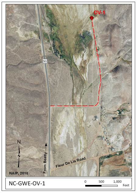
Access:
From Beatty (Main Street and S 2nd Street) take
US Highway 95 north about 7.3 miles and
turn right (about 0.4 miles north of Fleur De Lis
Road). Proceed about 0.3 miles east, and veer
north for about another 0.5 mile. NC-GWE-OV-1 is
located about 150 ft to the left of the road in the
meadow. It is on the other side of a
barbed-wire fence with an unlocked gate.
Click on the
thumbnail image for a larger view of the
image map.
Purpose
- Surface Water Conditions in Southern Nye County:
NC-GWE-OV-1 is one of two boreholes and
monitoring wells in
Oasis Valley to collect baseline flow
and chemical data in areas (far) down
gradient from previous nuclear tests.
Data:
|
RID |
Description |
Data |
Metadata |
Date |
|
Well
Completion Diagrams |
|
7907 |
NC-GWE-OV-1 Well Completion
Diagram |
rid7907.pdf |
meta7907.pdf |
4/15/11 |
|
Geophysical Data |
|
7861 |
NC-GWE-OV-1 Open Hole Geophysical
Logs, including: natural gamma, 8-, 16-,
32-, and 64-inch normal and lateral
resistivity, fluid temperature, fluid
resistivity, and caliper logs.
Data collected on 1/5/2011; Data are in
log ASCII format (.las).
|
rid7861.zip |
meta7861.pdf |
4/13/11 |
|
7867 |
NC-GWE-OV-1 Completion Geophysical
Logs, including: natural gamma, 8-, 16-,
32-, and 64-inch normal and lateral
resistivity, fluid temperature, fluid
resistivity, and density logs. Data
collected on 1/13/2011; Data are in
log ASCII format (.las).
|
rid7867.zip |
meta7867.pdf |
4/14/11 |
|
Ground Water Chemistry |
|
7966 |
NC-GWE-PV-1, PV-2, PV-3, 2P, 8PA,
Felderhoff-25-1PA, GF-3PA, GF-4, GF-4PA,
OV-1, OV-2, NPS well AM-0501 (GF-1), and Inyo BLM #1
Ground water chemistry results including
major ions, nutrients and metals from
ACZ Laboratories, Inc.; SIRA of nitrogen
in nitrate from Isotech Laboratory;
gross alpha and beta, radium, and
uranium from Radiation Safety
Engineering, Inc.; and SIRA of carbon in
TDIC, Radiocarbon (C-14) from Beta
Analytic for the
collection period from 3/21/2011 -
6/23/2011. |
rid7966.zip |
meta7966.pdf |
3/15/12 |
|
GPS Location Data |
|
7838.04 |
Post-processed Global Positioning System
(GPS) positions for wells NC-GWE-GF-3PA,
NC-GWE-GF-4, NC-GWE-GF-4PA, NC-GWE-OV-1
and NC-GWE-OV-2 |
rid7838_04.zip |
meta7838_04.pdf |
04/10/12 |
Abbreviations:
NAD 83
- North American Datum of 1983
AMSL
- Above Mean Sea Level
BGL
- Below Ground Level
BGS - Below Ground
Surface
GPM - Gallons Per Minute
GWE - Groundwater Evaluation
|
|
|