|
|
Well
No. NC-GWE-PV-2
SITE SUMMARY AND DATA |
|
Status:
Completed on
12/17/2010
Latitude/Longitude (NAD 83) - Approximate:
36°
16' 43.61" N
115° 58' 13.22" W
Legal Description:
T19S R53E S24 SW 1/4
|
Total Depth of Borehole
(ft): |
462.5 |
|
Total Depth of Well
(ft): |
452.5 |
|
Elevation of Ground Surface
(ft amsl): |
2964.0 |
|
Elevation of Water
(ft amsl): |
2606.5 |
|
Depth to Water
(ft bgl): |
357.5 |
|
Screened Interval
(ft bgl): |
362-442 |
|
Sandpack Depth
(ft bgs): |
356-463 |
|
Estimated Airlifted Water Production
(gpm): |
2-3 |
(depth
to water values based on post-drilling measurements
taken in March 2011)
|
|
|
Contact Intervals
(ft bgl) |
Stratigraphic Unit |
|
0-20 |
Silty Gravel with Sand |
|
20-462.5 |
Well Graded Gravel with Sand |
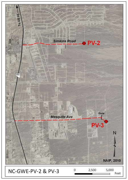
 Access:
From the intersection of Nevada Highway
160 and Simkins Road, head east on Simkins Road
about 1.7 miles. NC-GWE-PV-2 will be on the
left side of the road.
Click on the
thumbnail image for a larger view. Access:
From the intersection of Nevada Highway
160 and Simkins Road, head east on Simkins Road
about 1.7 miles. NC-GWE-PV-2 will be on the
left side of the road.
Click on the
thumbnail image for a larger view.
Purpose
- Groundwater Conditions in Pahrump Valley:
NC-GWE-PV-2 is one of five boreholes and wells
that were drilled to infill data gaps in the Water
Level Monitoring Program (WLMP),
especially on the Pahrump Fan.
Data:
|
RID |
Description |
Data |
Metadata |
Date |
|
Well
Completion Diagrams |
|
7903 |
NC-GWE-PV-2 Well Completion
Diagram |
rid7903.pdf |
meta7903.pdf |
4/15/11 |
|
Geophysical Data |
|
7846 |
NC-GWE-PV-2 Completion Geophysical
Logs, including: natural gamma, 8-, 16-,
32-, and 64-inch normal and lateral
resistivity, fluid temperature, fluid
resistivity, and density logs.
Data collected on 12/20/2010; Data are in
log ASCII format (.las). |
rid7846.zip |
meta7846.pdf |
4/14/11 |
|
7853 |
NC-GWE-PV-2 Open Hole Geophysical
Logs, including: natural gamma, 8-, 16-,
32-, and 64-inch normal and lateral
resistivity, fluid temperature, fluid
resistivity, and caliper logs.
Data collected on 12/17/2010; Data are in
log ASCII format (.las). |
rid7853.zip |
meta7853.pdf |
4/13/11 |
|
Ground Water Chemistry |
|
7966 |
NC-GWE-PV-1, PV-2, PV-3, 2P, 8PA,
Felderhoff-25-1PA, GF-3PA, GF-4, GF-4PA,
OV-1, OV-2, NPS well AM-0501 (GF-1), and Inyo BLM #1
Ground water chemistry results including
major ions, nutrients and metals from
ACZ Laboratories, Inc.; SIRA of nitrogen
in nitrate from Isotech Laboratory;
gross alpha and beta, radium, and
uranium from Radiation Safety
Engineering, Inc.; and SIRA of carbon in
TDIC, Radiocarbon (C-14) from Beta
Analytic for the
collection period from 3/21/2011 -
6/23/2011. |
rid7966.zip |
meta7966.pdf |
3/15/12 |
|
7974 |
NC-GWE-PV-1, PV-2, PV-3, 2P, 8PA,
Felderhoff-25-1PA, GF-3PA, GF-4, GF-4PA,
OV-2, NPS well AM-0501 (GF-1), and Inyo
BLM #1
Ground
water chemistry results including pH,
EC, SiO2, HCO3, CO3, Cl, SO4, NO3-N, Na,
K, Ca, Mg, DOC from Desert Research
Institute (DRI) Laboratory for the
collection period from 3/21/2011 -
6/23/2011. |
rid7974.zip |
meta7974.pdf |
3/29/12 |
|
GPS Location Data |
|
7838.01 |
Post-processed Global Positioning System
(GPS) positions for wells NC-GWE-PV-1,
PV-2, and PV-3 |
Superseded by RID 7838.02 |
Superseded by RID 7838.02 |
03/12/12 |
|
7838.02 |
Post-processed Global Positioning System
(GPS) positions for wells NC-GWE-PV-1
and NC-GWE-PV-2. |
rid7838_02.zip |
meta7838_02.pdf |
04/10/12 |
Abbreviations:
NAD 83 - North American Datum of 1983
AMSL - Above Mean Sea Level
BGL - Below Ground Level
BGS - Below Ground Surface
GPM - Gallons Per Minute
GWE - Groundwater Evaluation
|
|
|