
![]()


Well No. NC-EWDP-24PA SITE SUMMARY
Latitude/Longitude (Datum NAD-83):
36° 42' 15.874" North
116° 26' 52.258" West
Legal Description:
Township 14S Range 49E
Section 27 NE 1/4 SW 1/4Ground Elevation (Datum NGDV-29):
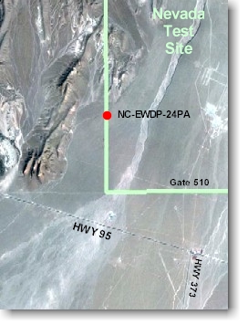
850.06 meters AMSL (2788.92 feet)Access: From the intersection of Highway 95 and Highway 373, go west on Highway 95 about 0.2 miles to the intersection of Highway 95 and the Gate 510 road. Go north 1.8 miles to Powerline Road, turn left (west) just south of the 510 gate, continue 2.5 miles along Powerline Road. Turn right just east of the Alluvial Tracer Complex (ATC) and continue approximately 2.1 miles along the road to the well site.
Purpose: The NC-EWDP-24PA borehole was designed to serve as a piezometer well with a single screen extending across the water table. Problems were encountered at approximately 152 feet while using under-reaming casing advance reverse circulation/air-rotary methods. The borehole was plugged back and abandoned.


