


Well No. NC-EWDP-9S SITE SUMMARY
Status: Exploratory Borehole (Abandoned)
Latitude/Longitude (Datum NAD-83):
36° 41' 44.613" North
116° 33' 46.723" WestLegal Description:
Township 14 S Range 48 E
Section 33 NE 1/4 NE 1/4 1/4Elevation (Datum NGVD-29):
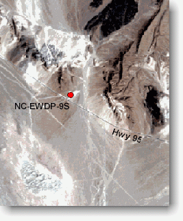
797.31 meters AMSL (2615.8 ft +/-) GPSAccess: Take Highway 95 from the Lathrop Wells Jct. 9.4 miles to the gate on the north side of the highway. Take the gravel road 0.3 miles and turn east.
Purpose: The purpose of the NC-EWDP-9S drillhole was to 1) provide lithologic samples of spring deposits; 2) define valley-fill stratigraphic sequence and groundwater flow paths down-gradient of proposed repository; and 3) provide water level and water chemistry data.
NC-EWDP-9S was drilled to 77.7 feet and core samples were logged. Drilling was stopped at NC-EWDP-9S due to drilling difficulties and lack of recovery. Drilling operations were moved to 9SX to complete the drilling objective at this general location.
