![]()


Well No. NC-EWDP-24P SITE SUMMARY
Status: Completed
Latitude/Longitude (Datum NAD-83):
36o 42' 16.775" North
116o 26' 52.756" WestLegal Description:
Township 14S, Range 49E, Section 27 NE 1/4 SW 1/4
Elevation (Datum NGVD-29):
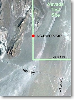
850.45 meters AMSL (2,790.19 feet) GPSAccess: From the intersection of Highway 95 and Highway 373, go west on Highway 95 about 0.2 miles to the intersection of Highway 95 and the Gate 510 road. Go north 1.8 miles to Powerline Road, turn left (west) just south of the 510 gate, continue 2.5 miles along Powerline Road, turn right just east of the Alluvial Tracer Complex (ATC) and continue approximately 2.1 miles along the road to the well site.
Purpose: NC-EWDP-24P was designed to serve as a hydrogeologic exploration borehole to approximately 2,000 feet below ground surface and to serve as a piezometer well with a single screen extending across the water table. The borehole was completed to 1,860 feet after meeting geologic objectives. Primary technical objectives include: 1) collect and geologically log continuous drill cutting samples and run borehole geophysical logs to approximately 1,860 feet; 2) use these data to define the stratigraphic sequence and to better characterize geologic structural boundaries immediately south of the proposed repository; and 3) provide water level and water chemistry data.