|
|
Well
No. NC-GWE-PV-1
SITE SUMMARY AND DATA |
|
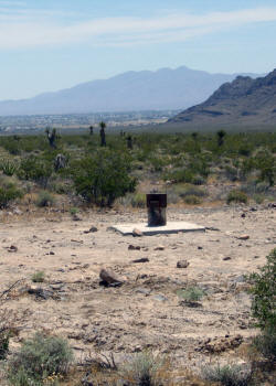
Status:
Completed on
12/22/2010
Latitude/Longitude (NAD 83) - Approximate:
36°
22' 24.96" N
116° 2' 35.50" W
Legal Description:
T18S R53E S20 SW 1/4
|
Total Depth of Borehole
(ft): |
610.0 |
|
Total Depth of Well
(ft): |
600.0 |
|
Elevation of Ground Surface
(ft amsl): |
3044.0 |
|
Elevation of Water
(ft amsl): |
2544.0 |
|
Depth to Water
(ft bgl): |
500.0 |
|
Screened Interval
(ft bgl): |
500-590 |
|
Sandpack Depth
(ft bgs): |
492-610 |
|
Estimated Airlifted Water Production
(gpm): |
2 |
(depth
to water values based on post-drilling measurements
taken in March 2011)
|
|
|
Contact Intervals
(ft bgl) |
Stratigraphic Unit |
|
0-20 |
Silty Gravel with Sand |
|
20-610 |
Well Graded Gravel with Sand |
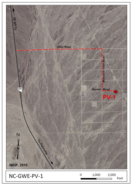
 Access:
From the intersection of Nevada Highway
160 and Ohio Road, head east on unpaved Ohio Road about 1.1
miles. Turn right (south) onto unpaved Mountain View
Road and proceed about 0.5 mile. Turn left
(east) onto Garnet Road and proceed about 0.2 miles.
NC-GWE-PV-1 will be on the right side of the road. Click on the
thumbnail image for a larger view. Access:
From the intersection of Nevada Highway
160 and Ohio Road, head east on unpaved Ohio Road about 1.1
miles. Turn right (south) onto unpaved Mountain View
Road and proceed about 0.5 mile. Turn left
(east) onto Garnet Road and proceed about 0.2 miles.
NC-GWE-PV-1 will be on the right side of the road. Click on the
thumbnail image for a larger view.
Purpose
- Groundwater Conditions in Pahrump Valley:
NC-GWE-PV-1 is one of five boreholes and wells
that were drilled to infill data gaps in the Water
Level Monitoring Program (WLMP),
especially on the Pahrump Fan.
Data:
|
RID |
Description |
Data |
Metadata |
Date |
|
Well
Completion Diagrams |
|
7906 |
NC-GWE-PV-1 Well Completion
Diagram |
rid7906.pdf |
meta7906.pdf |
4/15/11 |
|
Geophysical Data |
|
7845 |
NC-GWE-PV-1 Open Hole Geophysical
Logs, including: natural gamma, 8-, 16-,
32-, and 64-inch normal and lateral
resistivity, fluid temperature, fluid
resistivity, and caliper logs.
Data collected on 12/21/2010; Data are in
log ASCII format (.las). |
rid7845.zip |
meta7845.pdf |
4/13/11 |
|
7859 |
NC-GWE-PV1 Completion Geophysical
Logs, including: natural gamma, 8-, 16-,
32-, and 64-inch normal and lateral
resistivity, fluid temperature, fluid
resistivity, and density logs. Data
collected on 1/4/2011; Data are in
log ASCII format (.las). |
rid7859.zip |
meta7859.pdf |
4/14/11 |
|
Ground Water Chemistry |
|
7966 |
NC-GWE-PV-1, PV-2, PV-3, 2P, 8PA,
Felderhoff-25-1PA, GF-3PA, GF-4, GF-4PA,
OV-1, OV-2, NPS well AM-0501 (GF-1), and Inyo BLM #1
Ground water chemistry results including
major ions, nutrients and metals from
ACZ Laboratories, Inc.; SIRA of nitrogen
in nitrate from Isotech Laboratory;
gross alpha and beta, radium, and
uranium from Radiation Safety
Engineering, Inc.; and SIRA of carbon in
TDIC, Radiocarbon (C-14) from Beta
Analytic for the
collection period from 3/21/2011 -
6/23/2011. |
rid7966.zip |
meta7966.pdf |
3/15/12 |
|
7974 |
NC-GWE-PV-1, PV-2, PV-3, 2P, 8PA,
Felderhoff-25-1PA, GF-3PA, GF-4, GF-4PA,
OV-2, NPS well AM-0501 (GF-1), and Inyo
BLM #1
Ground
water chemistry results including pH,
EC, SiO2, HCO3, CO3, Cl, SO4, NO3-N, Na,
K, Ca, Mg, DOC from Desert Research
Institute (DRI) Laboratory for the
collection period from 3/21/2011 -
6/23/2011. |
rid7974.zip |
meta7974.pdf |
3/29/12 |
|
GPS Location Data |
|
7838.01 |
Post-processed Global Positioning System
(GPS) positions for wells NC-GWE-PV-1,
PV-2, and PV-3 |
Superseded by RID 7838.02 |
Superseded by RID 7838.02 |
03/12/12 |
|
7838.02 |
Post-processed Global Positioning System
(GPS) positions for wells NC-GWE-PV-1
and NC-GWE-PV-2. |
rid7838_02.zip |
meta7838_02.pdf |
04/10/12 |
Abbreviations:
NAD 83
- North American Datum of 1983
AMSL - Above Mean Sea Level
BGL - Below Ground Level
BGS - Below Ground Surface
GPM - Gallons Per Minute
GWE - Groundwater Evaluation
|
|
|