|

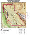
In 1999, the U.S. Geologic Survey (USGS) Geologic Division
conducted an aeromagnetic survey in southern Nye
County. The
aeromagnetic survey of southern Nye County includes most
of the Amargosa Desert, Pahrump Valley, Furnace Creek
Wash, and intervening areas.
This area includes a number of geologic structures
identified in geologic mapping and geophysical studies
that are critical to our understanding of the subsurface
framework that controls ground water movement in the
Death Valley Ground Water Flow System. The particular
areas of interest include:
-
Devil's Hole and
Point of Rock
-
North-south
Amargosa structural trough and bounding Ash Meadows
fault zone
-
State Line fault in
Ash Meadows and Pahrump Valley
-
Intersection of
Rock Valley fault and Amargosa structural trough
-
Southern boundary
of the southwest Nevada volcanic complex
-
Faults that may lie
along Fortymile Wash
-
Structures
suspected to exist along Highway 95 near Amargosa
Valley
-
Areas immediately
affecting Nye County's Early Warning Drilling
Program
-
Volcanic rocks of
the Greenwater Range and southernmost Funeral Range
-
Faults that may
exist beneath Furnace Creek Wash
The final
report and aeromagnetic data are available from the USGS
for download:
http://pubs.usgs.gov/of/2000/of00-188/
Blakely, R. J., V. E. Langenheim, D. A. Ponce, and G. L.
Dixon, 2000. "Aeromagnetic Survey of the Amargosa
Desert, Nevada and California: A Tool for Understanding
Near-Surface Geology and Hydrology."
|

